The Lysterfield MTB Park is one of the better places to mountain bike in Melbourne.
A solid collection of trails for all riders, proper signage & mapping and a balance of technical & flow features.
In the car, the trails are located about 45min South East of central Melbourne. They are easily accessible with excellent car parking and trailhead facilities.
The network of trails is well known amongst mtb riders in Melbourne and the park is well visited, especially on weekends.
Whilst not massive, with about 24km of trail, they are fun to ride, well built and easy to find your way.
Overview of Lysterfield MTB Park
As with many mountain bike trails in Melbourne and surrounds, these trails were built throughout the 80’s and 90’s as the sport bloomed, however the trails were unsanctioned and built without permission of the land manager or owner.
Fast-forward several years and as the sport’s popularity increased, mountain biking has now become a key driver for visitation and revenue for parks and local business that rely on users, at the park.
The trails received a significant injection of investment in infrastructure and trail building, as a location for the mountain bike events during the 2006 Commonwealth Games in Melbourne.
Since this period, the trails have been in various states of management and trail building status, driven by large numbers of riders riding ‘Lysty’.
This popularity has led to better trail building and maintenance, excellent signage and mapping and good trailhead facilities (car parking, toilets, water, BBQ’s etc.).
There used to be a café/bike shop at the trailhead (Trailmix), unfortunately this closed a number of years ago. Let’s hope another operator opens at the park again.
Getting to Lysterfield Lake Mountain Bike Park
There are a couple of locations to reach the trails and park your car.
The first is via the main park entrance via Horswood Rd, Narre Warren East. As you enter the gates of the park, the trailhead and large map is to your immediate left, with car parking available on both sides of the road.
The other popular location for parking is the Hallam North Road Car Park, located in Lysterfield South. This carpark is at the foot of the Comm Games and start of the Hug trail.
Top Lysterfield MTB Trails
The bulk of the trails at Lysterfield mountain bike park can be ridden in a long loop, which is across mostly blue and black graded trails. Riding the loop anti-clockwise, from the main trailhead at Lysterfield Lake Park, is the suggested direction.
Outside of this, you can dip in and out of sections, depending on ability, to master or just enjoy on repeat.
Beginner Mountain Biking Trails
The Lake Circuit Trail also known, as the Lysterfield Lake Walk is the main beginner trail an as the name suggests, circles the lake. The trail is wide and shared with walkers to make up a 6km loop.
The trail also links up the to the short section of the Trailmix trail, that weaves its way through the east side of the carpark and has some tighter singletrack.
The park also features a skills section and pump track at the southern end of the lake.
Intermediate Trails
The Lysterfield Park mtb trails are largely made up of intermediate tracks that can be ridden to create a solid loop.
The twisty and slightly uphill ‘Lower Buckle’, the fast and flowy section with a couple of hits along the ‘Middle’ or the fast and twisty ‘Hug’ and ‘Lower Blair Witch’.
All these trails can be ridden in the anti-clockwise loop around the lake for an ideal hit out ride.
Advanced Trails
At the end of the ‘Red Gum’ trail, there is a couple of link trails and road to connect you with the advanced trails at the Lysterfield bike park.
This is where you can experience the loop used at the Commonwealth Games. A switchback climb up the top of the rise and then a fast singletrack downhill section that enters several berms and corners before climbing out through the granite rocks and ending with fast straight.
There are no massive jumps, more fast and techy to get its ‘Advanced’ trail rating, but more an intermediate trail.
Lysterfield MTB Map
There are a couple of options for viewing the Lysterfield mountain bike map.
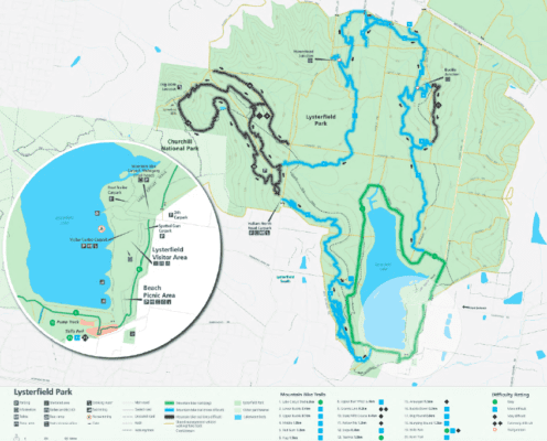
You can download the Lysterfield Lake map pdf here and print out as a hard copy.
Or you can use an app like TrailForks to view the Lysterfield Lake map
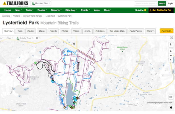
If it is your first time here (or third or tenth), to get the best out of the loop, head to the main Lysterfield mtb trailhead parking area, at the entrance of the park. From here, follow the signs in the anti-clockwise direction and you should be good to go.
The park and trails are well signed to make navigating for first time visitors to the park easy.
Planning your Lysterfield Mountain Biking Trip
Whilst there is plenty of parking, weekends from 10am onwards can get busy. No issues if you were going mid-week.
While the trails can be ridden all year round, the Parks Vic site has information regarding hazards or trail closures that is updated regularly.
If you need last minute bike supplies, the closet bike shop to the main park entrance is in Hallam. They are open on the weekend, from 10am.
2/10 Hallam South Rd,
Hallam
+61 3 8795 1600
Post MTB Ride Activities – Lysterfield Lake
With the closure of the Trailmix café, and no information on when this facility my reopen, there are no cafes onsite. However there is a café/restaurant (Stella’s Kitchen) right next to the main entrance of the park, at the apple orchard.
Due to busy weekends, you may need to book if dining in.
On the west side, near the Hallam North Rd carpark is another quality café option – the Grounded Grocer.
Given that Lysterfield Park is largely surrounded by urban areas, there a multiple options to get your post-ride food fix.
There are also BBQ’s and picnic facilities for a more extravagant, end of ride feed.
Final Thoughts of Lysterfield Mountain Bike Trails
The Lysterfield MTB park was one of the early trail centres to be established in Melbourne. It has a solid selection of trails and terrain that leans towards the more technical, singletrack style of trail.
The location and graded trails also works well for beginners and kids, as well as non-riding people, in your group. The lake and parklands are pretty special and visitor numbers on the weekends explodes, particularly in spring & summer.
It is easy enough to combine multiple loops or repeat certain sections, to extend your riding time.
It’s pretty good for trails in greater Melbourne, but this is not alpine riding, so some more advanced riders may find this a little tame. It depends on what you want to get out of it.
It is certainly worth the visit, to knock out a couple laps and mix up the riding. Enjoy!


Pingback: Exploring the Woodend MTB Trails: Your Guide to the Wombat Tracks - Trail Voyage